NASA's Terra satellite passed over Tropical Cyclone Ava as it continued moving away from the island nation of Madagascar. Ava was located in the Southern Indian Ocean, off the southeastern coast of the country.
NASA's Terra satellite passed over Tropical Cyclone Ava as it continued moving away from the island nation of Madagascar. Ava was located in the Southern Indian Ocean, off the southeastern coast of the country.
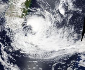
The Moderate Resolution Imaging Spectroradiometer or MODIS instrument aboard NASA's Terra satellite provided a visible image of Tropical Cyclone Ava early on Jan. 8. The image showed most of the thunderstorms were in the eastern quadrant of the storm.
At 10 a.m. EST (1500 UTC) the center of Tropical Storm Ava was located near 27.2 degrees south and 48.2 degrees east longitude. That’s about 521 nautical miles southeast of Europa Island. Ava was moving to the southwest at 14 knots and had maximum sustained winds near 40 mph (46 mph/74 kph).
Read more at NASA/Goddard Space Flight Center
Image: NASA's Terra satellite provided a visible image of Tropical Cyclone Ava early on Jan. 8. The image showed most of the thunderstorms were in the eastern quadrant of the storm. (Credit: NASA Rapid Response Team)


