Counting individuals of a species is important in order to track wildlife trends. Absence or decline of a species could mean detrimental habitat modifications or that parts of the ecosystem are unbalanced. For marine populations though, trying to count and monitor these species is often a daunting and expensive task as finding these individuals in the vast ocean can be like looking for a needle in a haystack. Thankfully, scientists lead by the British Antarctic Survey (BAS) have demonstrated how new satellite technology can be used to count whales, and ultimately estimate their population size.
Counting individuals of a species is important in order to track wildlife trends. Absence or decline of a species could mean detrimental habitat modifications or that parts of the ecosystem are unbalanced. For marine populations though, trying to count and monitor these species is often a daunting and expensive task as finding these individuals in the vast ocean can be like looking for a needle in a haystack.
!ADVERTISEMENT!
Thankfully, scientists lead by the British Antarctic Survey (BAS) have demonstrated how new satellite technology can be used to count whales, and ultimately estimate their population size.
Using Very High Resolution (VHR) satellite imagery, alongside image processing software, scientists were able to automatically detect and count whales breeding in part of the Golfo Nuevo, Peninsula Valdes in Argentina.
Lead author Peter Fretwell from the BAS, which is funded by the UK’s Natural Environment Research Council (NERC), explains; "This is a proof of concept study that proves whales can be identified and counted by satellite. Whale populations have always been difficult to assess; traditional means of counting them are localized, expensive and lack accuracy. The ability to count whales automatically, over large areas in a cost effective way will be of great benefit to conservation efforts for this and potentially other whale species."
The BAS team used a single WorldView2 satellite image of a bay where southern right whales gather to calve and mate. Driven to near extinction, these whales have made a limited recovery following the end of whaling. In recent years, however, many deaths have been seen on their nursery grounds at Peninsula Valdes. Their population size is now unknown but with this sharp increase in calf mortality, estimates are needed.
The enclosed bays in this region contain calm, shallow waters which increase the chance of spotting the whales from space. Three main criteria were used to identify whales: objects visible in the image should be the right size and shape; they should be in the right place (where whales would be expected to be) and there should be no (or few) other types of objects that could be mistaken as whales.
As a result of the satellite imagery, 55 probable whales, 23 possible whales and 13 sub-surface features were identified.
Future satellite platforms will provide even high quality imagery. This will allow for greater confidence in identifying whales and differentiating mother and calf pairs.
The study is published this week in the journal PLoS ONE.
Read more at the British Antarctic Survey.
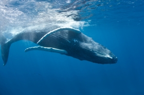
Whale image via Shutterstock.


