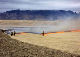
An examination of long-term data for lands managed by the Bureau of Land Management finds that land treatments in the southwestern United States are increasingly large, expensive and related to fire and invasive species control.
The study, recently published in Restoration Ecology, reveals an extensive legacy of land management decisions and provides new insight on strategies to increase future treatment efficacy in an extremely water-limited region.
>> Read the Full Article
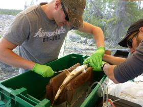
Canadian scientists have discovered that certain lake predators are altering their behaviour due to climate change, revealing what the future may hold for these fish and their food.
For years scientists told tales of fish such as Lake Trout adapting their feeding behaviour as temperatures change, but no empirical evidence existed. Now, a recently completed 11-year study at IISD Experimental Lakes Area (IISD-ELA) in northwestern Ontario reveals that Lake Trout have a remarkable ability to adjust their behaviour in the face of changing water temperatures.
>> Read the Full Article
It was a pretty typical day for NASA scientists studying pollution in the Hampton Roads region of southeastern Virginia — busy, in other words.
And for good reason. The work they were doing could help improve air-quality forecasts in a region where the air quality picture isn’t totally clear.
>> Read the Full Article

MIT and Harvard University researchers have engineered E. coli cells that can be used to study how bacteria at an infection site respond to antibiotic treatment, allowing scientists to learn more about how existing antibiotics work and potentially help them to develop new drugs.
In the new study, which appears in the Aug. 31 issue of Cell Host and Microbe, the researchers found evidence that some existing hypotheses about how bacteria respond to antibiotics are not correct.
>> Read the Full Article
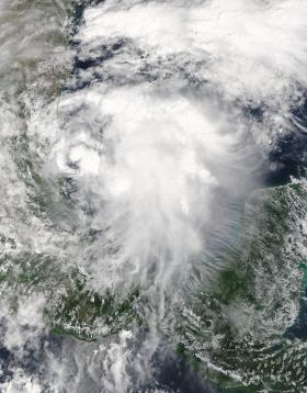
NASA’s Terra satellite passed over Tropical Storm Katia as it was developing along Mexico’s east coast. On Sept. 5, the thirteenth tropical depression of the Eastern Pacific Ocean hurricane season formed about 80 miles (125 kph) east of Tampico, Mexico, in the western Gulf of Mexico.
The Moderate Resolution Imaging Spectroradiometer or MODIS instrument that flies aboard NASA’s Terra satellite captured a visible-light image of the depression as it was organizing on Sept. 5 at 1:10 p.m. EDT (1710 UTC). The image showed that deep convection and thunderstorms were forming over the center. By 4 p.m. EDT, the National Hurricane Center noted that the depression had formed.
>> Read the Full Article
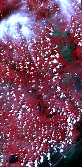
On Sept. 5, 2017, the Advanced Spaceborne Thermal Emission and Reflection Radiometer (ASTER) instrument on NASA's Terra spacecraft captured this image of the area around Bay City, Texas, about 50 miles (80 kilometers) southwest of Houston. Hurricane Harvey caused extensive inland flooding, seen as dark blue areas where the water is relatively clear, and green-grey where the water carries sediment. The image covers an area of 32 by 65 miles (52 by 105 kilometers), and is centered at 29.2 degrees north, 95.8 degrees west.
>> Read the Full Article


