The hot, dry conditions in Indiana may have one bright spot - creating a more fiery display of fall leaves in some parts of the state. But that's not much solace for farmers, gardeners, boaters and fishermen plagued by a weather system that shows no signs of dissipating soon.
WEST LAFAYETTE, Ind. -The hot, dry conditions in Indiana may have one bright spot - creating a more fiery display of fall leaves in some parts of the state. But that's not much solace for farmers, gardeners, boaters and fishermen plagued by a weather system that shows no signs of dissipating soon.
During the first half of August, a streak of 14 consecutive days of 90 degrees or hotter was recorded in Indianapolis, the longest such hot period since 1983. In addition to the heat, a dry spell that began during April persisted and worsened, with much of central Indiana experiencing its driest period during this time frame since 1966. Some portions of eastern Indiana experienced the driest conditions in 53 years, said Logan Johnson of the National Weather Service's Indianapolis office. The result is an increased area of the state labeled in the moderate to severe drought categories and a further drop of soil moisture, groundwater and reservoir levels, and river flow.
While recent rains are welcome, they are still scattered around the state and won't change the overall picture for areas affected by the unusually dry conditions, said Dev Niyogi, state climatologist at the Purdue University-based Indiana State Climate Office.
Weather factors indicate that through November there is an enhanced likelihood of continued above-normal temperatures for most of the state and continued widely scattered precipitation, Johnson said. Indiana is stuck in a neutral weather pattern that has halted rain from the tropics and the West, major sources of precipitation for Indiana in a normal summer.
Though these conditions are sobering, Niyogi said it's part of the Midwest's climate variability.
!ADVERTISEMENT!
"While more research is clearly needed, at this point it does not seem likely that the current drought is anything different than a naturally occurring variation in our climate pattern," said Niyogi, who also is a Purdue assistant professor of agronomy and earth and atmospheric sciences. "We have had a highly variable drought this year with counties showing some areas that are not impacted while other parts of the same county have severe drought."
The 2007 weather statistics create a mosaic effect on color-keyed precipitation and temperature maps compiled from information gathered by volunteers with the Cooperative Weather Service Network and the Community Collaborative Rain, Hail and Snow Network. The National Weather Service, U.S. Department of Agriculture, National Oceanic and Atmospheric Administration, and Indiana State Climate Office create the maps and analyze the information.
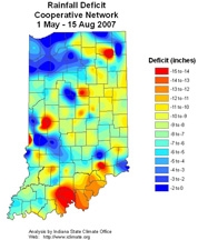
A brightly colored map of the rainfall deficit from May 1 to Aug. 15 shows exactly what Niyogi means about the wide variations. For instance, DeKalb County in the northeast, Jennings County in the southeast and Vigo County in the west-central portion of Indiana each showed as little as no deficit to a 2-inch surplus of rain to as high as a 15-inch deficit for May 1 to Aug. 15 when compared to a normal year.
During the first two weeks of August, Indiana temperatures ranged from 5.3 degrees to 7.5 degrees higher than normal, with the former recorded in the state's northern area and the latter in south-central Indiana. Precipitation for the same period was 25 percent of normal in the west-central part of the state, while Indiana's northeast corner received 142 percent of normal rainfall.
Almost two-thirds of the state was classified as being in moderate to severe drought as of Aug. 14, compared to about one-half of Indiana the week before. The agencies use a drought monitor scale with five levels: abnormally dry, moderate drought, severe drought, extreme drought and exceptional drought.
Drought is determined by various factors resulting from lack of rainfall, but high temperatures worsen dry conditions and also impact how much rain falls or how quickly soil moisture evaporates, Niyogi said.
The summer began with normal to wetter conditions in Indiana. Through May 15, none of the state was classified as being abnormally dry or in a drought state. From late 2006 through early 2007, a surplus of rain fell, so deep groundwater levels remained high, Johnson said.
Since May the high temperatures and lack of rain have increased water usage, causing groundwater levels to steadily decline. In addition, lake and reservoir water levels, and levels and flow in streams have nosedived in most of the state.
Three of the reservoirs that supply water to Indianapolis - Geist, Eagle Creek and Morse - are at their lowest levels in 10-15 years, Johnson said. Morse is at its third-lowest level on record, and these historically low levels have created several navigational hazards for recreational boaters, especially on the lake's south end.
Stream flow in most of northern Indiana is normal or above normal, but most of the rest of the state's streams and rivers have flows below normal to much below, associate state climatologist Ken Scheeringa said.
"The areas of stream flow concern are in central and south-central Indiana and perhaps some parts of east-central," Scheeringa said. "Many streams in these areas are running less than 25 percent of normal. It's interesting that, even so, there is a mix of near normal stream flow within the low-flow areas, indicative of the large variability in rainfall within short distances."
According to the Midwestern Regional Climate Center, Indiana's soil moisture now ranges from 0.5 inches more than normal in the northwesternmost corner of the state to 3 inches less than normal in the south-central tip.
"The curtailed rainfall since May signaled the settling in of the drought," Niyogi said. "Now even areas that have received some recent heavy rains are mired in drought."
Soil moisture can recover quickly once precipitation returns to normal, he said. But stream flow and groundwater may take one to three years to rebound. This could have long-term consequences for some sectors.
"The crops and floral landscape are greatly impacted, and businesses and recreation that rely on water will be also. We don't yet know what the economic significance will be for those sectors, but clearly it will be quite significant," Niyogi said.
The only thing about this drought that could make some people smile is that the unusual heat could mean leaves as colorful as the weather maps.
"For the southern part of the state, we have anecdotal evidence that the leaves may be more fiery red during the fall color season," Niyogi said.
Writer: Susan A. Steeves, (765) 496-7481, This email address is being protected from spambots. You need JavaScript enabled to view it.
Sources: Dev Niyogi, (765) 494-6574, This email address is being protected from spambots. You need JavaScript enabled to view it.
Kenneth Scheeringa, (765) 494-8105, This email address is being protected from spambots. You need JavaScript enabled to view it.
Logan Johnson, (317) 856-0360, ext. 510, This email address is being protected from spambots. You need JavaScript enabled to view it.
Ag Communications: (765) 494-2722;
Beth Forbes, This email address is being protected from spambots. You need JavaScript enabled to view it.
Agriculture News Page
Note to Journalists: Precipitation and temperature maps are available online at / http://www.agry.purdue.edu/climate


