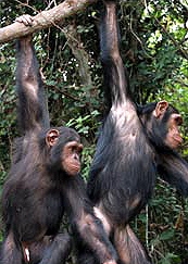
Congo, Africa - Using state-of-the-art geospacial technology, scientists are mapping one of the last uncharted wilderness regions on the planet, with an eye to protecting the ecosystem that supports the Bonobo chimpanzee, one of our closest evolutionary relatives ane scores of other animals.
Located in the remote south east Democratic Republic of Congo, the 56,000-square-kilometre tract of forest remains little known to outsiders. The biological importance of the region—called Tshuapa-Lomami-Lualaba, or TL2 — has been hinted at for more than four decades. But today inventories are being conducted within forest sectors, focusing on areas of interest to monitor the presence of the endangered bonobo chimpanzee, as well as a rich variety of monkey species, okapi, Congo peacock, large ungulates, elephants and much more.
Congo, Africa - Using state-of-the-art geospacial technology, scientists are mapping one of the last uncharted wilderness regions on the planet, with an eye to protecting the ecosystem that supports the Bonobo chimpanzee, one of our closest evolutionary relatives ane scores of other animals.
Located in the remote south east Democratic Republic of Congo, the 56,000-square-kilometre tract of forest remains little known to outsiders. The biological importance of the region—called Tshuapa-Lomami-Lualaba, or TL2 — has been hinted at for more than four decades. But today inventories are being conducted within forest sectors, focusing on areas of interest to monitor the presence of the endangered bonobo chimpanzee, as well as a rich variety of monkey species, okapi, Congo peacock, large ungulates, elephants and much more.“The world has a rare opportunity here to preserve and protect from development what is almost untouched natural habitat,” says Dr. Kerry Bowman, founder of the Canadian Ape Alliance, one of the groups working to assess the ecosystem. “We believe that once we demonstrate the level of endangered life within TL2, we’ll have a good case for the preservation of part or maybe all of the area.”
In partnership with the Democratic Republic of Congo’s Lukuru Wildlife Research Foundation (LWRF), members of the Toronto-based wildlife conservation group are combining sparse preexisting data—some of it dating back to the 19th century—with the researchers’ daily discoveries. The results are being used to provide real-time digital mapping support and analysis to those in the wilderness.
As the expedition makes its way up river in a dugout canoe, the Canadian team stays in contact with satellite phone, helping the team track their position, log their discoveries, and decide where to explore next.
In 2005, the Alliance received an ESRI Conservation Grant. Along with generous hardware and equipment support from Trimble Corporation and WESA, its GIS project team is working closely with LWRF to develop an accurate and comprehensive base map for immediate and future field conservation applications.Existing geospatial data is very limited for the region and general in nature, with basic hydrology, topography and cultural features available from a variety of sources (CARPE, FAO, UNEP, UNDP, UNOCHA, WRI).
"Right now, our GIS focus is rebuilding a hydrographic layer for the mapping, using hard-copy maps ranging in date from 1880s to post-2000, plus satellite imagery and other earlier digital map data,” says Nick January, GIS Project Manager with the Canadian Ape Alliance. “That data is being supplied to field survey teams on the ground in remote spots through satellite phone ftp downloads, and giving them much-needed geographic information for travelling through the region."
The field survey teams are also conducting ground-truthing to verify land classifications obtained through satellite imagery, and field training will be executed in 2008 with the GIS/GPS components.
Data collected in the field or at occasional base camps using mobile integrated GPS/GIS units (ESRI ArcPad on Trimble GeoXTs) will be incorporated into a larger-scale GIS for storage, maintenance, analysis, cartographic output and report production. In the long-term, the collected field data will substantially increase the quality and quantity of geospatial data for the region.
The project is expected to continue for at least two more years.
The Canadian Ape Alliance advances conservation and awareness of all Great Apes and the environments they live in by respecting human need. All conservation strategies are designed to reflect local cultures, as well as economic and political realities. The work of the Canadian Ape Alliance can be found at www.great-apes.com.
Dr. Kerry Bowman has a Ph.D. in Bioethics, a fellowship in Cultural Psychiatry, and a Masters degree in Social Work. He is an Assistant Professor appointed to both University of Toronto Joint Centre for Bioethics and The University of Toronto Centre for Environment. As well, he is the Clinical Ethicist for Mount Sinai Hospital in Toronto. As the president and founder of The Canadian Ape Alliance he travels frequently to eastern Democratic Republic of Congo as a conservationist and environmentalist working to help protect the great apes of Africa. His primary focus is on balancing environmental protection with the promotion of human well being, and he is currently also working with the United Nations Environment Programme (UNEP), and is a member of the Board of Directors of The Jane Goodall Institute.
Nick January is a Geographic Information Systems (GIS) Specialist with a broad-based technical expertise in all areas of geospatial technologies. Over the last 17 years he has worked in a variety of environments, gaining extensive experience in conservation GIS, municipal government GIS applications and hydrographic field surveying. He also has an academic background in primate conservation (BSc & MSc in progress) and is applying geospatial sciences to African wildlife conservation issues with the Canadian Ape Alliance (www.great-apes.com). As GIS Project Manager, Nick is ideally situated to develop a close working partnership with the Lukuru Wildlife Research Foundation project in the Tshuapa-Lomami-Lualaba river basins, lending technical support to the project.


