
MIAMI (Reuters) - U.S. researchers are ramping up their use of unmanned, remote-controlled airplanes this year to penetrate the heart of Atlantic hurricanes in the hope of learning more about what makes the giant storms tick.
By Jim Loney
MIAMI (Reuters) - U.S. researchers are ramping up their use of unmanned, remote-controlled airplanes this year to penetrate the heart of Atlantic hurricanes in the hope of learning more about what makes the giant storms tick.
But they will be flying the rugged drones from the eastern Caribbean island of Barbados because American aviation authorities won't let them launch the tiny aircraft from U.S. soil out of concern they could endanger other planes.
Nonetheless, storm researchers are confident their drones, which resemble hobbyists' model airplanes but can be controlled by satellites, will give them a more complete picture of the core of cyclones than they've ever had before.
!ADVERTISEMENT!The drones can fly into the eye of a storm just 300 feet
above the sea surface and send back a constant stream of temperature, pressure, wind and humidity readings.
"It can get measurements we couldn't get otherwise," said Joe Cione, a research meteorologist with the U.S. National Oceanic and Atmospheric Administration.
"That area of the storm is critical because that's where the maximum winds are. It will give us a better understanding of where the energy is extracted out of the sea."
Made by Australia's Aerosonde Pty Ltd. and worth between $50,000 and $80,000, the unmanned aircraft measure just 7-feet
long, have a 9-foot (2.7-metre) wingspan, and weigh only 28 pounds (12.7 kg).
They are much smaller and less sophisticated than those used by the U.S. military in war zones. Powered by a tiny 24 cc motor and a single propeller, they can fly at about 70 mph (113 kph) and cover an astonishing 2,000 miles on a single 0.66 U.S. gallon (2.5-litre) tank of fuel, Cione said.
They are catapulted into flight or launched from a moving vehicle, and are initially flown using a joystick before control is transferred to a laptop and then to satellite.
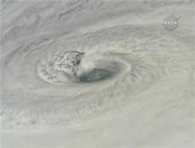
Unlike the manned hurricane hunter aircraft used for years to penetrate cyclones at around 10,000 feet, the Aerosondes will fly a few hundred feet above the ocean, where the critical energy transfer from sea surface to storm occurs.
HUGE IMPROVEMENT
A continuous data stream promises a huge improvement over the sporadic measurements scientists have taken for years using "dropsondes," packages of instruments flung from a plane which take "snapshots" as they fall through the storm.
"It's the difference between taking a photograph and taking a movie," Cione said. "You're not going to miss anything."
The researchers have dabbled with drones before, starting with Tropical Storm Ophelia in 2005. An unmanned aircraft spent 17.5 hours aloft in a flight into Hurricane Noel last year.
This year they are hoping for two to five flights.
But for at least this hurricane season -- which starts Saturday and runs for six months -- the drones will explore far from U.S. shores. The Federal Aviation Administration has not given NOAA approval to fly them from U.S. territory.
The agency has issued more than 100 approvals for unmanned aircraft on projects ranging from searches for illegal aliens along the U.S. border to wildfire surveillance.
But the FAA said it must be sure the drones could be flown safely from a U.S. base into an approaching hurricane, a time when many pilots are moving small planes out of harm's way.
"You have a situation where you have a small aircraft that has no real ability to see and avoid other aircraft, transiting an area that might have civilian aircraft in it," FAA spokesman Les Dorr said.
Hurricane researchers look forward to the eventual approval of U.S. flights to give them a chance to study hurricanes nearing the coast for signs of the explosive intensity surges scientists find most worrisome.
"Once that option's available to us, we'll be all over it," Cione said. "That's in the FAA's camp."
Forecasters frankly admit that predicting sudden, rapid intensification is one of their weaknesses. A relatively mild hurricane approaching a crowded shore can become a destructive cyclone with winds over 130 mph (210 kph) after residents have gone to bed, leaving little time to evacuate once they awaken.
A better picture of the inner core, the eye wall and especially the energy exchange at the sea surface that fuels hurricanes offers a chance to improve intensity forecasting.
"Personally, my feeling is that we can make leaps and bounds -- big, pioneering changes in our understanding of intensity," Cione said.
(Editing by Eric Beech)


