
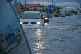
Heavy rainfall and the problems of flooding in towns have never been far from peoples' minds or the news headlines over the past few weeks. Now scientists say that new research will help to accurately pinpoint which individual streets are most at risk from flooding during severe rainstorms.
The Environment Agency, Met Office and others use computer models to predict how heavy rainfall moves over the land surface. But the models can't show exactly where the rain will accumulate and cause problems.
!ADVERTISEMENT!
Professor Paul Bates from the University of Bristol has been working on this problem for much of the last decade. He and his colleague, Dr Ad de Roo from the EU Joint Research Centre in Italy, decided to rethink the physics behind the complex and expensive computer models.
'Instead of loading more and more physical processes into the prediction model we decided to turn it on its head and find a simpler way,' says Bates. The pair worked out the minimum amount of physics needed to improve the model's predictive skill over a large area and at high resolution.
Bates and de Roo developed a new two-dimensional flood inundation programme which they have improved over the years, creating a blueprint that has saved industry years of developer time. Before they developed this programme it would have been far too expensive and taken too many computer resources to predict where flooding would occur.
'Some of the major players are now using our programme code,' says Bates. 'We're working with the Met Office to write the code into their forecast models. We've developed something that's so efficient it will become feasible to simulate surface water flooding at a high resolution over whole cities – it's good enough to identify individual streets where properties could be affected.'
As a proof of concept, Bates says that they are planning to simulate a very large area – such as South-west England or the whole of Wales – and combine their model with the Met Office rainfall forecast.
'This is really still at an experimental stage,' says Bates. 'But five or ten years down the line we could be doing this routinely as part of the weather forecast.'
Article continues at Planet Earth Online
Flooded Street image via Shutterstock


