NASA's Aqua satellite provided a birds-eye view of Tropical Cyclone Ernie as it was being battered by strong vertical wind shear and torn apart.
NASA's Aqua satellite provided a birds-eye view of Tropical Cyclone Ernie as it was being battered by strong vertical wind shear and torn apart.
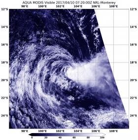
NASA's Aqua satellite passed over Ernie on April 10 at 0720 UTC (3:20 a.m. EST) and the Moderate Resolution Imaging Spectroradiometer or MODIS instrument took a visible image of the storm. The image showed that strong vertical wind shear had pushed the bulk of clouds and thunderstorms east and southeast of the center of circulation.
The Joint Typhoon Warning Center or JTWC issued their final warning on Ernie at 0900 UTC (5 a.m. EST) on April 9. At that time Ernie's maximum sustained winds were near 40 knots (46 mph/74 kph) and weakening quickly. It was away from land areas, about 660 nautical miles west-northwest of Learmonth, Western Australia. It was centered near 17.4 degrees south latitude and 107.6 degrees east longitude. Ernie was moving to the west-southwest at 12 knots (13.8 mph/22.2 kph).
Read more at NASA/Goddard Space Flight Center
Image: NASA's Aqua satellite passed over Ernie on April 10 at 0720 UTC (3:20 a.m. EST saw strong vertical wind shear had pushed the bulk of clouds and thunderstorms southeast of the center of circulation. (Credit: NASA/NRL)


