Shortly after lasers were first developed in the 1960s, LiDAR – whose name originated as a combination of “light” and “radar” – capitalized on the newly unique precision they offered for measuring both time and distance. LiDAR quickly became the standard method for (3-D) land surveys and is now used in a multitude of sensing applications, such as self-driving cars.
By scanning areas of land with lasers, often from airplanes, LiDAR’s travel-time measurements for light reflected back from the scanned area provide the distances that make up a resulting high-resolution topography.
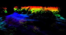
As laser and electronic technology evolved, LiDAR’s abilities adapted to overcome several limitations and obscuring effects unavoidably produced by real environments, like dynamic weather patterns. With a specially designed laser system and a new methodology based on gated digital holography, research from the Naval Research Laboratory, in Washington, D.C., now provides a method to give LiDAR an enhanced ability to see through otherwise obscuring elements of terrain like foliage or netting. Paul Lebow, from the Naval Research Laboratory, will present this work at The Optical Society’s Imaging and Applied Optics Congress, held 26 -29 June, 2017 in San Francisco, California.
“This was an attempt to address one of the problems with something called foliage-penetrating LiDAR,” Lebow said. “You can actually use it to detect three-dimensional images behind an obscuration such as a tree canopy, for instance, in a disaster relief situation where you wanted to find people in trouble. You can illuminate using LiDAR through the leaves and get enough light coming back through to be able to recreate a three-dimensional, topographic view of what’s going on beneath.”
Continue reading at The Optical Society
Image: Researchers from the Naval Research Laboratory use gated digital holography methods to develop foliage penetrating LiDAR that can survey obscured ground (Credits: US Naval Research Laboratory)


