The sixth tropical depression of the Eastern Pacific Ocean hurricane season formed near southwestern Mexico and quickly strengthened into Tropical Storm Fernanda. NASA’s Aqua satellite provided infrared imagery of the strengthening storm.
The sixth tropical depression of the Eastern Pacific Ocean hurricane season formed near southwestern Mexico and quickly strengthened into Tropical Storm Fernanda. NASA’s Aqua satellite provided infrared imagery of the strengthening storm.
Tropical Depression 6E formed on July 11 at 11 p.m. EDT (July 12 at 0300 UTC) about 740 miles (1,190 km) south of the southern tip of Baja California, Mexico.
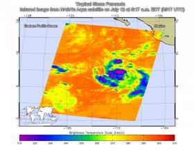
Infrared satellite imagery from the Atmospheric Infrared Sounder or AIRS instrument that flies aboard NASA's Aqua satellite taken on July 12 at 5:17 a.m. EDT (0917 UTC) provided a look at the temperatures of Tropical Depression 6E's clouds. That data was false colored and made into an image at NASA's Jet Propulsion Laboratory in Pasadena, California to highlight cloud top temperatures. In infrared imagery, the coldest cloud tops indicate towering thunderstorms high into the troposphere. The colder the clouds, the stronger the storms. AIRS data showed that some cloud tops around the center of circulation were as cold as minus 63 degrees Fahrenheit or minus 53 degrees Celsius. Cloud top temperatures that cold have been shown to generate heavy rainfall.
Read more at NASA/Goddard Space Flight Center
Image: This infrared image of Tropical Depression 6E, later named Fernanda, was taken on July 12 at 5:17 a.m. EDT (0917 UTC) just to the south of southwestern Mexico. The purple areas indicate coldest cloud tops and strongest storms. (Credit: NASA JPL/Ed Olsen)


