Earlier this year Arctic sea ice sank to a record low wintertime extent for the third straight year. Now NASA is flying a set of instruments north of Greenland to observe the impact of the melt season on the Arctic's oldest and thickest sea ice.
Earlier this year Arctic sea ice sank to a record low wintertime extent for the third straight year. Now NASA is flying a set of instruments north of Greenland to observe the impact of the melt season on the Arctic's oldest and thickest sea ice.
Operation IceBridge, NASA’s airborne survey of polar ice, launched a short campaign on July 17 from Thule Air Base, in northwest Greenland. Weather permitting, the IceBridge scientists are expecting to complete six, 4-hour-long flights focusing on sea ice that has survived at least one summer. This older multiyear ice, once the bulwark of the Arctic sea ice pack, has dramatically thinned and shrunk in extent along with the warming climate: in the mid-1980s, multi-year ice accounted for 70 percent of total winter Arctic sea ice extent; by the end of 2012, this percentage had dropped to less than 20 percent.
“Most of the central Arctic Ocean used to be covered with thick multiyear ice that would not completely melt during the summer and reflect back sunshine,” said Nathan Kurtz, IceBridge’s project scientist and a sea ice researcher at NASA’s Goddard Space Flight Center in Greenbelt, Maryland. “But we have now lost most of this old ice and exposed the open ocean below, which absorbs most of the sun’s energy. That’s one reason the Arctic warming has increased nearly twice the global average— when we lose the reflecting cover of the Arctic Ocean, we lose a mechanism to cool the planet.”
Read more at NASA/Goddard Space Flight Center
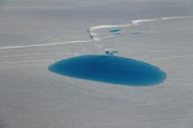
Image: A large circular sea ice floe covered with melt ponds and surrounded by smaller floes, as seen from an Operation IceBridge flight on July 17, 2017. (Credit: NASA/Nathan Kurtz)


