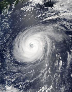
NASA’s Aqua satellite is keeping track of Typhoon Noru as it continues its slow trek through the Northwestern Pacific Ocean.
On August 2, 2017 at 12:05 a.m. EDT (0405 UTC) the Moderate Resolution Imaging Spectroradiometer or MODIS instrument that flies aboard NASA’s Aqua satellite captured a visible image of Typhoon Noru. The MODIS image shows a symmetric band of thunderstorms completely surrounding a well-defined eye feature.
Noru has been around for 13 days since it formed on July 21 about 230 miles nautical miles north-northeast of Minami Tori Shima. The storm moved to the southwest and once it moved southeast of Iwo To Island, Noru then turned to the northwest and is now west of the island.
Read more at National Aeronautics and Space Administration (NASA)
Photo: On August 2, 2017 at 12:05 a.m. EDT (0405 UTC) NASA’s Aqua satellite captured a visible image of Typhoon Noru that showed a symmetric band of thunderstorms completely surrounding a well-defined eye feature. Credits: NASA Goddard MODIS Rapid Response Team


