When NASA-NOAA’s Suomi NPP satellite passed over Tropical Storm Franklin instruments aboard provided a night-time view of the storm’s clouds and measured their temperatures, revealing a strengthening storm.
The Visible Infrared Imaging Radiometer Suite (VIIRS) instrument aboard the NASA-NOAA Suomi NPP satellite captured infrared images of Franklin on August 8 at 3:58 a.m. EDT (0758 UTC). The Suomi NPP night-time image showed that Franklin’s northwestern edge had not yet reached San Francisco de Campeche or Merida, as the lights of both cities were still visible in the image. The infrared image provided temperatures of Franklin’s cloud tops, where thunderstorms surrounding the low-level center were as cold as 190 Kelvin (minus 117.7 degrees Fahrenheit / minus 83.1 degrees Celsius). NASA research has shown that storms with cloud top temperatures that cold have the ability to generate very heavy rainfall.
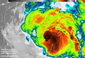
By early August 9, Franklin’s center had slipped off land and emerged into the Bay of Campeche in the southwestern Gulf of Mexico.
Read more at NASA / Goddard Space Flight Center
Image: An infrared image of Franklin from NASA-NOAA Suomi NPP satellite on August 8 at 3:58 a.m. EDT (0758 UTC showed cloud tops surrounding the low-level center were as cold as 190 Kelvin (minus 117.7 degrees Fahrenheit / minus 83.1 degrees Celsius).
Credits: NASA / NOAA / UWM-CIMSS, William Straka III


