Satellite imagery showed that Tropical Depression 15E continued to struggle to organize while still being affected by vertical wind shear.
Satellite imagery showed that Tropical Depression 15E continued to struggle to organize while still being affected by vertical wind shear.
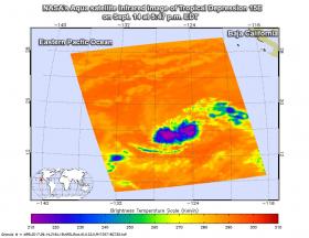
The AIRS instrument aboard NASA’s Aqua satellite captured infrared temperature data on Tropical Depression 15E’s clouds on Sept. 14 at 5:47 p.m. EDT (2147 UTC). Strongest thunderstorms were in two areas around the center. The National Hurricane Center (NHC) noted that “Just like it has on several previous occasions already, convection has decreased near the center of the depression. That said, the fact that there even is deep convection near the center is still an improvement compared to 24 hours ago.”
NHC forecaster Zelinsky noted “if convection near the center of the depression can persist, the cyclone may finally begin to slowly intensify.”
Continue reading at NASA / Goddard Space Flight Center
Image: The AIRS instrument aboard NASA’s Aqua satellite captured this image of Tropical Depression 15E on Sept. 14 at 5:47 p.m. EDT (2147 UTC), and purple indicates the strongest storms.
Credits: NASA JPL, Ed Olsen


