Although Tropical Storm Jose was located off the coast of southeastern U.S. it is stirring up the waters along the U.S. East coast, causing dangerous conditions. NOAA’s GOES East satellite saw Jose centered about 360 miles northeast of the southwestern Bahamas on Sept. 15.
Although Tropical Storm Jose was located off the coast of southeastern U.S. it is stirring up the waters along the U.S. East coast, causing dangerous conditions. NOAA’s GOES East satellite saw Jose centered about 360 miles northeast of the southwestern Bahamas on Sept. 15.
The National Hurricane Center said “Jose is expected to produce high surf and life-threatening rip currents along portions of the U.S. East coast.”
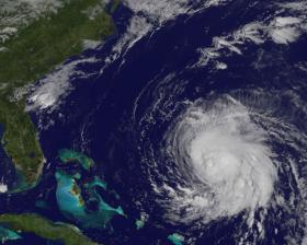
On Sept. 15, 2017 at 9:30 a.m. EDT (1330 UTC), NOAA’s GOES East satellite captured a visible image of the Tropical Storm Jose northwest of the Bahamas. NHC noted that Jose is showing signs of becoming better organized. The low-level center is embedded well within a growing central dense overcast.
The NASA/NOAA GOES Project at NASA's Goddard Space Flight Center in Greenbelt, Maryland created an image. NOAA manages the GOES series of satellites and the NASA/NOAA GOES Project creates images and animations from the data.
Continue reading at NASA / Goddard Space Flight Center
Image: On Sept. 15, 2017 at 9:30 a.m. EDT (1330 UTC), NOAA’s GOES East satellite captured this visible image of the Tropical Storm Jose northwest of the Bahamas.
Credits: NASA / NOAA GOES Project


