Former Hurricane Otis was not showing any thunderstorm development or precipitation on satellite imagery on Sept. 19. As a result, the National Hurricane Center declared Otis a remnant low pressure area.
Former Hurricane Otis was not showing any thunderstorm development or precipitation on satellite imagery on Sept. 19. As a result, the National Hurricane Center declared Otis a remnant low pressure area.
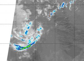
NASA's Aqua satellite got a last look at the dying storm on Sept. 19 at 4:35 a.m. EDT (0935 UTC). That's when the Moderate Resolution Imaging Spectroradiometer or MODIS instrument aboard NASA's Aqua satellite analyzed Otis' cloud top temperatures in infrared light.
MODIS found cloud top temperatures had warmed significantly over the previous 12 hours and there was just one lone band of thunderstorms south of the center where temperatures were as cold as minus 50 degrees Fahrenheit. The clouds over the center of the circulation were much warmer and were not generating any precipitation.
Read more at NASA/Goddard Space Flight Center
Image: The MODIS instrument aboard NASA's Aqua satellite got a last infrared look at Otis' remnants on Sept. 19 at 4:35 a.m. EDT (0935 UTC). There was just one area of cold clouds (yellow) in a band south of the center.
Credits: NASA/NRL


