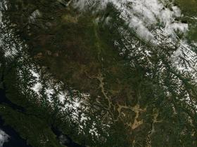
This past summer Canada has been plagued with huge forest fires that have spanned most of the provinces. British Columbia has been particularly hard hit with large portions of the landscape being decimated by fire. In these satellite images taken by the NASA'S Aqua satellite, both the natural color and false color burn scars of left by fires can be seen. In the natural color image it is difficult to make out the burn scars. The false color easily identifies areas where fire has left a scar showing a brownish-red color. Currently there are 745 wildfires larger than 0.01 hectares and all wildfires of note (active or out) in British Columbia as of today, Sept. 29. (Wildfire link updates daily). NASA's Aqua satellite collected this natural-color image with the Moderate Resolution Imaging Spectroradiometer, MODIS, instrument on September 27, 2017.
This past summer Canada has been plagued with huge forest fires that have spanned most of the provinces. British Columbia has been particularly hard hit with large portions of the landscape being decimated by fire. In these satellite images taken by the NASA'S Aqua satellite, both the natural color and false color burn scars of left by fires can be seen. In the natural color image it is difficult to make out the burn scars. The false color easily identifies areas where fire has left a scar showing a brownish-red color. Currently there are 745 wildfires larger than 0.01 hectares and all wildfires of note (active or out) in British Columbia as of today, Sept. 29. (Wildfire link updates daily). NASA's Aqua satellite collected this natural-color image with the Moderate Resolution Imaging Spectroradiometer, MODIS, instrument on September 27, 2017.
Continue reading at NASA/Goddard Space Flight Center
Image Credits: NOAA/NASA Goddard MODIS Rapid Response Team


