The Northwestern Pacific Ocean generated another tropical depression hours after a different system quickly faded. NASA’s Aqua satellite provided a look at Tropical Depression 27W after it developed about 300 miles from Chuuk. Earlier in the day, Tropical Depression 26W dissipated in the South China Sea.
The Northwestern Pacific Ocean generated another tropical depression hours after a different system quickly faded. NASA’s Aqua satellite provided a look at Tropical Depression 27W after it developed about 300 miles from Chuuk. Earlier in the day, Tropical Depression 26W dissipated in the South China Sea.
On Oct. 19 at 5 a.m. EDT (0900 UTC) Tropical Depression 26W was dissipating under adverse conditions to the west of Philippines. Twelve hours later, Tropical Depression 27W formed far west of the dying depression. On Oct 19 at 5 p.m. EDT (2100 UTC), Tropical depression 27W (27W) formed about 282 nautical miles north of Chuuk.
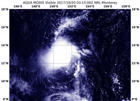
NASA’s Aqua satellite captured a look at Tropical Depression 27W on Oct. 20 at 0315 UTC (Oct. 19 at 11:15 p.m. EDT). The Moderate Resolution Imaging Spectroradiometer or MODIS instrument aboard Aqua provided a visible image of the storm that showed it was still disorganized. The Joint Typhoon Warning Center noted that infrared imagery showed weak flaring, fragmented, and disorganized convection that is obscuring an ill-defined low level circulation.
Read more at NASA/Goddard Space Flight Center
Image: NASA's Aqua satellite captured a look at Tropical Depression 27W on Oct. 20 at 0315 UTC (Oct. 19 at 11:15 p.m. EDT) that showed it was still disorganized. (Credit: NASA/NRL)


