About 40 percent of northern Malaysian Borneo’s carbon stocks exist in forests that are not designated for maximum protections, according to new remote sensing and satellite mapping from Carnegie’s Greg Asner and his colleagues.
About 40 percent of northern Malaysian Borneo’s carbon stocks exist in forests that are not designated for maximum protections, according to new remote sensing and satellite mapping from Carnegie’s Greg Asner and his colleagues.
Asner’s flying laboratory, the Carnegie Airborne Observatory, was able to map carbon stocks that—together with satellite imaging and other geospatial data—will guide conservation efforts undertaken by the Sabah Forestry Department in Malaysian Borneo, the Southeast Asia Rainforest Research Partnership (SEARRP), the PACOS Trust, BC Initiative and other organizations.
“We are proud to be part of this groundbreaking endeavor in the state of Sabah, which sets us apart in accelerating the quest and capacity to protect, restore, and conserve more high-conservation and high-carbon forests in this country,” said Sam Mannan, Chief Conservator of Forests. “We shall apply the information gathered for the common good of society, particularly, in mitigating against the worst effects of climate change. This project is of immense value to tropical forest management.”
Read more at Carnegie Institution for Science
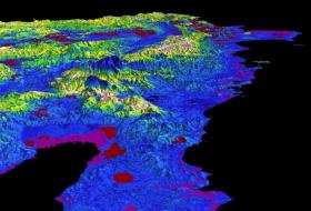
Image: Maps show the density of aboveground carbon stocks in the Sabah state of Malaysia on the island of Borneo. Mapping forest carbon is an important step in identifying areas for conservation, but is tremendously difficult to accomplish without airborne and satellite technology.
Image Credit: Greg Asner / The Carnegie Airborne Observatory


