NASA’s Aqua satellite passed over the South China Sea and obtained a visible light image of the first depression of the Northwestern Pacific Ocean basin’s 2018 tropical cyclone season. Vertical wind shear can be deadly to tropical cyclones and satellite data showed Tropical Depression Bolaven, formerly known as 01W, was being adversely affected by it.
NASA’s Aqua satellite passed over the South China Sea and obtained a visible light image of the first depression of the Northwestern Pacific Ocean basin’s 2018 tropical cyclone season. Vertical wind shear can be deadly to tropical cyclones and satellite data showed Tropical Depression Bolaven, formerly known as 01W, was being adversely affected by it.
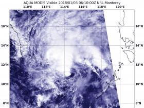
On Jan. 3 at 1:10 a.m. EST (0610 UTC) the Moderate Resolution Imaging Spectroradiometer or MODIS instrument aboard Aqua provided a visible look at the effect wind shear was having on Bolaven. Southeasterly wind shear had pushed the bulk of clouds to the northwestern quadrant of the storm, leaving the rest of the circulation exposed and with just fragmented clouds.
On Jan. 3 at 10 a.m. EST (1500 UTC), Tropical Depression Bolaven was located near 11.7 degrees north latitude and 112.6 degrees east longitude, about 391 nautical miles east of Ho Chi Minh City, Vietnam. Bolaven’s maximum sustained winds were near 30 knots (34.5 mph/55.5 kph). The depression was moving to the west-northwest at 16 knots (18.4 mph/29.6 kph).
Read more at NASA/Goddard Space Flight Center
Image: On Jan. 3 at 1:10 a.m. EST (0610 UTC) NASA's Aqua satellite provided a visible look at the effect wind shear was having on Bolaven, pushing the bulk of clouds northwest of the center. (Credits: NASA/NRL)


