The total shoreline of the world’s lakes is more than four times longer than the global ocean coastline. And if all the water in those lakes were spread over the Earth’s landmass, it would form a layer some four feet (1.3 metres) deep.
Those are just two of the big-picture findings to emerge from the most complete global database of lakes to date, compiled by geographers at McGill University. Their research, published in Nature Communications, promises to help scientists better understand the important role of lakes in the Earth’s complex environmental systems – from the hydrological cycle and weather patterns, to the transport, distribution or storage of pollutants and nutrients through the landscape.
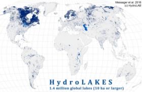
“Lakes are changing, in a changing world,” says senior author Bernhard Lehner, an associate professor in McGill’s Department of Geography. “Some are disappearing as there is less water to keep them filled, others are created or growing in regions where there is more rainfall. So we need a good inventory of the current status of lakes to understand and monitor their changes and the effects that this may have for our global environment.”
Filling data gaps
While there are plenty of measurements for lakes in some regions of the world, significant gaps have remained in the global data. In principle, the surface area or shoreline length of a lake can be directly measured on maps or satellite images, for example, but it’s much more difficult and time-consuming to estimate the amount of water stored beneath a lake’s surface.
An intuitive theory has long held that lakes in hilly or mountainous regions should tend to be deeper than those in flat landscapes. But until recently, it wasn’t easily possible to determine a clear relationship between the degree of hilliness and the depth of a lake.
Continue Reading at McGill University
Photo via McGill University


