NASA looked at the rainfall rates within Tropical Storm Gert as it continued to strengthen and found the most intense rainfall on the tropical cyclone's eastern side. Just over 12 hours later, Gert would strengthen into a hurricane. As Gert has strengthened, the storm began generating dangerous surf along the U.S. East coast.
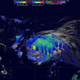
The Global Precipitation Measurement mission or GPM core observatory satellite passed above tropical storm Gert on August 14, 2017 at 9:36 a.m. EDT (1336 UTC) when winds had reached about 57.5 mph (50 knots). Data collected by GPM's Microwave Imager (GMI) and Dual-Frequency Precipitation Radar (DPR) instruments were used to show the coverage and the intensity of rainfall around Tropical Storm Gert. The area covered by GPM's radar swath revealed that the most intense rainfall, measuring greater 3.5 inches (90 mm) per hour, was located in bands of rain on the eastern side of the storm.
NASA looked at the rainfall rates within Tropical Storm Gert as it continued to strengthen and found the most intense rainfall on the tropical cyclone's eastern side. Just over 12 hours later, Gert would strengthen into a hurricane. As Gert has strengthened, the storm began generating dangerous surf along the U.S. East coast.
The Global Precipitation Measurement mission or GPM core observatory satellite passed above tropical storm Gert on August 14, 2017 at 9:36 a.m. EDT (1336 UTC) when winds had reached about 57.5 mph (50 knots). Data collected by GPM's Microwave Imager (GMI) and Dual-Frequency Precipitation Radar (DPR) instruments were used to show the coverage and the intensity of rainfall around Tropical Storm Gert. The area covered by GPM's radar swath revealed that the most intense rainfall, measuring greater 3.5 inches (90 mm) per hour, was located in bands of rain on the eastern side of the storm.
That GPM pass was mentioned in a National Hurricane Center (NHC) Tropical Storm Gert Discussion that noted, "A recent 1336 UTC (9:36 a.m. EDT) GMI overpass shows a large band of convection wrapping around the circulation ..."
At NASA's Goddard Space Flight Center in Greenbelt, Maryland, GPM's Radar (DPR Ku Band) data was used to create a 3-D cross-section view through Gert. This examination of the storm's 3-D precipitation structure showed that the tallest thunderstorms were located in an intense band of rain east of Gert's center. The tall thunderstorms in that band were shown by DPR to reach altitudes above 9.4 miles (15.2 km). GPM is a joint mission between NASA and the Japan Aerospace Exploration Agency, JAXA.
Continue reading at NASA / Goddard Space Flight Center
Image: The GPM core observatory satellite passed above tropical storm Gert on August 14 at 9:36 a.m. EDT (1336 UTC) and found the most intense rainfall, measuring greater 3.5 inches (90 mm) per hour on the eastern side of the storm. The tall thunderstorms in that area reached altitudes above 9.4 miles (15.2 km). Credits: NASA / JAXA, Hal Pierce


