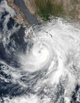
Hurricane Lidia’s eye was visible in NASA satellite imagery as it approached Baja California, Mexico’s southernmost tip. Hurricane Lidia was making landfall on the Baja on Sept. 1 at 5 a.m. PDT and continued to bring soaking rains to the region.
Hurricane Lidia’s eye was visible in NASA satellite imagery as it approached Baja California, Mexico’s southernmost tip. Hurricane Lidia was making landfall on the Baja on Sept. 1 at 5 a.m. PDT and continued to bring soaking rains to the region.
NASA-NOAA’s Suomi NPP satellite passed over Hurricane Lidia on Aug. 31 at 4:24 p.m. EDT (2024 UTC). The Visible Infrared Imaging Radiometer Suite (VIIRS) instrument aboard took a visible light picture of the storm when the eye was just southwest of the southern tip of Baja California. Thunderstorms in Lidia’s eastern quadrant had already spread over mainland Mexico.
Earlier in the day, NASA’s Aqua satellite passed over Lidia and analyzed the storm in infrared light as it strengthened quickly. Infrared data provides temperature information and the highest, coldest cloud tops in tropical cyclones indicate where the strongest storms are located. NASA’s AIRS instrument provides that critical temperature information.
Read more at NASA/Goddard Space Flight Center
Image: NASA-NOAA's Suomi NPP satellite passed over Hurricane Lidia on Aug. 31 at 4:24 p.m. EDT (2024 UTC) when the eye was just southwest of the southern tip of Baja California. (Credit: NOAA/NASA Goddard Rapid Response Team)


