The storm formerly known as tropical cyclone 15S, now called Tropical Cyclone Ernie continued to strengthen as NASA's Aqua satellite captured a visible image that showed the storm developed an eye.
The storm formerly known as tropical cyclone 15S, now called Tropical Cyclone Ernie continued to strengthen as NASA's Aqua satellite captured a visible image that showed the storm developed an eye.
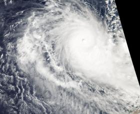
NASA's Aqua satellite passed over Ernie on April 7 at 0645 UTC (2:45 a.m. EST) and the Moderate Resolution Imaging Spectroradiometer or MODIS instrument took a visible image of the storm. The image showed an eye had formed as the storm strengthened into a hurricane. Thick bands of powerful thunderstorms surrounded the eye.
Read more at NASA / Goddard Space Flight Center
Image: NASA's Aqua satellite passed over Ernie on April 7 at 0645 UTC (2:45 a.m. EST) and saw an eye had formed as the storm strengthened into a hurricane. Thick bands of powerful thunderstorms surrounded the eye.
Credits: NASA


