
Data from NAA's Landsat 8 is now freely available, enabling researchers and the general public to access images captured by the satellite within twelve hours of reception. The data is available to download at no charge from GloVis, EarthExplorer, or via the LandsatLook Viewer. Landsat 8 launched this February and has been capturing images since April. The satellite orbits Earth every 99 minutes and captures images of every point on the planet every 16 days, beaming 400 high resolution images to ground stations every 24 hours. Landsat features nine spectral bands, which include three visible light bands, two near-infrared bands, and two shortwave infrared (SWIR) bands, among others, as well as two thermal sensors, which are used for a wide range of applications, including monitoring environmental change, detecting fires, and watching crops. Google is one of the biggest commercial users of Landsat images, which feed into Google Earth, but other users include scientists and conservationists involved in tracking deforestation and forest degradation.
Data from NAA's Landsat 8 is now freely available, enabling researchers and the general public to access images captured by the satellite within twelve hours of reception. The data is available to download at no charge from GloVis, EarthExplorer, or via the LandsatLook Viewer.
!ADVERTISEMENT!
Landsat 8 launched this February and has been capturing images since April. The satellite orbits Earth every 99 minutes and captures images of every point on the planet every 16 days, beaming 400 high resolution images to ground stations every 24 hours. Landsat features nine spectral bands, which include three visible light bands, two near-infrared bands, and two shortwave infrared (SWIR) bands, among others, as well as two thermal sensors, which are used for a wide range of applications, including monitoring environmental change, detecting fires, and watching crops. Google is one of the biggest commercial users of Landsat images, which feed into Google Earth, but other users include scientists and conservationists involved in tracking deforestation and forest degradation.
For the conservation community, the launch of Landsat 8 is a welcome development. Conservationists say they intend to use imagery captured by Landsat to monitor forest cover in near-real time, potentially enabling authorities to take action against illegal deforesters. In the past, Landsat images have provided an important baseline for tracking land use change over time, including the expansion of oil palm plantations in Malaysia and Indonesia, conversion of rainforests for industrial timber production in Sumatra, selective logging of rainforests in Peru, and deforestation for soy farms and cattle ranches in the Brazilian Amazon.
Landsat data can also help forest conservation projects under the proposed Reducing Emissions from Deforestation and Forest Degradation (REDD+) quantify reductions in carbon emissions, potentially generating cash for forest-dependent communities and project developers.
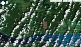
Image shows landsat-based image of Tebingtinggi, Riau Province, Sumatra displayed on Google Earth.
Read more at ENN Affiliate, MongaBay.


