NASA’s Aqua satellite provided infrared imagery Hurricane Hilary that showed it weakening. Within 12 hours the storm weakened to a tropical storm.
NASA’s Aqua satellite provided infrared imagery Hurricane Hilary that showed it weakening. Within 12 hours the storm weakened to a tropical storm.
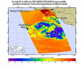
Infrared satellite imagery from the Atmospheric Infrared Sounder or AIRS instrument that flies aboard NASA's Aqua satellite taken on July 27 at 4:59 p.m. EDT (2059 UTC) provided a look at the temperatures of Hilary’s clouds. That data was false colored and made into an image at NASA's Jet Propulsion Laboratory in Pasadena, California to highlight cloud top temperatures.
The data showed that the deep convection and building thunderstorms associated with Hilary was decreasing late on July 27. The convective pattern became limited to a ragged central dense overcast. This loss of convection appears to be associated with dry air that has wrapped into the circulation.
In infrared imagery, the coldest cloud tops indicate towering thunderstorms high into the troposphere. The colder the clouds, the stronger the storms. AIRS data showed that a small area of cloud tops around the south of the center of circulation were as cold as minus 63 degrees Fahrenheit or minus 53 degrees Celsius. Cloud top temperatures that cold have been shown to generate heavy rainfall.
Read more at NASA/Goddard Space Flight Center
Image: On July 27 at 4:59 p.m. EDT (2059 UTC) NASA's Aqua satellite provided a look at the temperatures of Hilary's clouds and saw strong storms (purple) limited to a small area south of the center as it continued weakening. (Credit: NASA JPL/Ed Olsen)


