NASA’s Aqua satellite passed over Typhoon Nesat as the storm continued moving north toward Taiwan.
NASA’s Aqua satellite passed over Typhoon Nesat as the storm continued moving north toward Taiwan.
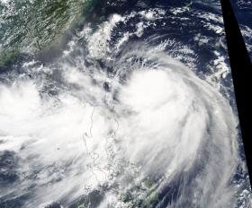
On July 27 at 1:30 p.m. local time the Moderate Resolution Imaging Spectroradiometer or MODIS instrument aboard NASA’s Aqua satellite captured a visible image of the storm that showed powerful thunderstorms surrounding the center of circulation and a large thick band of storms wrapping into the center from the south and east. Although a ragged eye could not be seen in the MODIS imagery, it was visible using other satellite data.
Nesat is moving through the Northwestern Pacific Ocean and is expected to make landfall and cross central Taiwan on July 29.
On July 28 at 5 a.m. EDT (0900 UTC) the Joint Typhoon Warning Center said that Typhoon Nesat’s maximum sustained winds were near 65 knots (75 mph/120 kph). At that time the center was located near 20.6 degrees north latitude and 125.3 degrees east longitude. That’s about 342 nautical miles southeast of Taipei, Taiwai. Nesat was moving toward the northwest near 8 knots (9.7 mph/14.8 kph).
Read more at NASA/Goddard Space Flight Center
Image: On July 27 NASA's Aqua satellite captured a visible image of Typhoon Nesat northeast of the Philippines in the Northwestern Pacific Ocean. (Credit: NASA Goddard MODIS Rapid Response Team)


