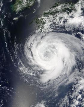
NASA's Terra satellite passed over Typhoon Noru early on August 3 and saw that high clouds had moved over the eye.
NASA's Terra satellite passed over Typhoon Noru early on August 3 and saw that high clouds had moved over the eye.
On Aug. 3 at 0135 UTC (Aug. 2 at 9:35 p.m. EDT) the Moderate Resolution Imaging Spectroradiometer or MODIS instrument aboard NASA's Terra satellite captured a visible-light image of Noru tracking through the Northwestern Pacific Ocean. The image showed the eye had become filled with high clouds. Microwave data clearly showed the eye was present, so forecasters understood the clouds were high clouds and the entire eye had not filled in throughout.
At 11 a.m. EDT (1500 UTC) on August 3 Typhoon Noru's maximum sustained winds were near 85 knots (97 mph/157 kph). The storm was centered near 28.2 degrees north latitude and 133.8 degrees east longitude. That's about 348 nautical miles east-northeast Kadena Air Base, Okinawa (Island), Japan.
Read more at NASA/Goddard Space Flight Center
Image: On Aug. 4 at 02:20 UTC (Aug. 3 at 10:20 p.m. EDT) NASA's Terra satellite captured this image of Typhoon Noru approaching Kyushu, Japan and showed that its eye was 37 nautical miles wide. (Credit: NASA Goddard MODIS Rapid Response Team)


