NASA’s Aqua satellite observed fragmented feeder bands of strong thunderstorms spiraling into the low-level center of Tropical Cyclone Doksuri.
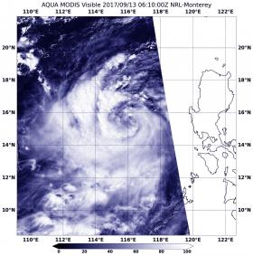
On Sept. 13 at 2:10 a.m. EDT (0610 UTC) the Moderate Resolution Imaging Spectroradiometer or MODIS instrument that flies aboard NASA’s Aqua satellite captured a visible-light image of the storm as it moved west in the South China Sea. Fragmented bands of thunderstorms spiraled into the center from the western and southern sides of the storm.
NASA’s Aqua satellite observed fragmented feeder bands of strong thunderstorms spiraling into the low-level center of Tropical Cyclone Doksuri.
On Sept. 13 at 2:10 a.m. EDT (0610 UTC) the Moderate Resolution Imaging Spectroradiometer or MODIS instrument that flies aboard NASA’s Aqua satellite captured a visible-light image of the storm as it moved west in the South China Sea. Fragmented bands of thunderstorms spiraled into the center from the western and southern sides of the storm.
Tropical depression 21W strengthened into a tropical storm and was renamed “Doksuri.”
Read more at NASA / Goddard Space Flight Center
Image: On Sept. 13 at 2:10 a.m. EDT (0610 UTC) the MODIS instrument aboard NASA’s Aqua satellite captured this visible image of Typhoon Doksuri in the South China Sea.
Credits: NASA Goddard MODIS Rapid Response Team


