Hurricane Maria was analyzed in visible and infrared light as NASA-NOAA's Suomi NPP passed overhead over two days. NASA's GPM satellite also provided a look at Maria's rainfall rates.
Hurricane Maria was analyzed in visible and infrared light as NASA-NOAA's Suomi NPP passed overhead over two days. NASA's GPM satellite also provided a look at Maria's rainfall rates.
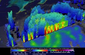
On Sept. 23 at 8:12 a.m. EDT (1212 UTC) the Global Precipitation Measurement mission or GPM core observatory estimated of hourly rainfall in multiple intense rainfall bands of thunderstorms around Maria's western side. Rain was found falling at a rate of over 6.57 inches (137 mm) per hour and some thunderstorm tops in these rain bands were found to reach heights above 9.7 miles (15.7 km). GPM is managed by NASA and the Japan Aerospace Exploration Agency.
Read more at NASA/Goddard Space Flight Center
Image: On Sept. 23 at 8:12 a.m. EDT (1212 UTC) the GPM core observatory estimated of hourly rainfall in multiple intense rainfall bands of thunderstorms around Maria's western side. Rain was found falling at a rate of over 6.57 inches (137 mm) per hour and some thunderstorm tops in these rain bands were found to reach heights above 9.7 miles (15.7 km).
Credits: NASA/JAXA, Hal Pierce


