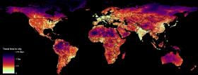
While people live within one hour of a city in over 90% of cases in high-income countries - concentrated in Europe and North America - for low-income countries concentrated in sub-Saharan Africa, the figure is 50.9%.
While people live within one hour of a city in over 90% of cases in high-income countries - concentrated in Europe and North America - for low-income countries concentrated in sub-Saharan Africa, the figure is 50.9%.
These figures are one result of work from a team of researchers, led by Oxford University and with expert input from the JRC, now published in Nature. In mapping urban accessibility worldwide, the study provides an actionable dataset that will support global and local decision-making on development and environmental policies.
The results of the study confirm that the economic and manmade resources that sustain human wellbeing are not distributed evenly across the world, but are instead heavily concentrated in cities. Poor access to the opportunities and services offered by urban centres is a major barrier to improved livelihoods and overall development.
By further triangulating this map against socioeconomic datasets, the scientists demonstrate how access to urban centres stratifies the economic, educational, and health status of humanity.
Read more at European Commission Joint Research Centre
Image: The map shows a global visualisation of travel time to the city with the shortest associated journey. (Credit: 2018 OpenStreetMap contributors, creative commons attribution 4.0)


