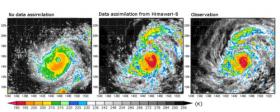
Using the power of Japan’s K computer, scientists from the RIKEN Advanced Institute for Computational Science and collaborators have shown that incorporating satellite data at frequent intervals—ten minutes in the case of this study—into weather prediction models can significantly improve the rainfall predictions of the models and allow more precise predictions of the rapid development of a typhoon.
Weather prediction models attempt to predict future weather by running simulations based on current conditions taken from various sources of data. However, the inherently complex nature of the systems, coupled with the lack of precision and timeliness of the data, makes it difficult to conduct accurate predictions, especially with weather systems such as sudden precipitation.
As a means to improve models, scientists are using powerful supercomputers to run simulations based on more frequently updated and accurate data. The team led by Takemasa Miyoshi of AICS decided to work with data from Himawari-8, a geostationary satellite that began operating in 2015. Its instruments can scan the entire area it covers every ten minutes in both visible and infrared light, at a resolution of up to 500 meters, and the data is provided to meteorological agencies. Infrared measurements are useful for indirectly gauging rainfall, as they make it possible to see where clouds are located and at what altitude.
Continue reading at RIKEN
Image via RIKEN


