
The US Geological Survey reports that earthquake related deaths numbered 1783 worldwide, a big decrease from 2008 when more than 88,000 died, with more than 87,000 of the deaths occurring in the Eastern Sichuan, China earthquake in May 2008. In 2009, the worst earthquake was the September 30th earthquake in Southern Sumatra, Indonesia in which 1,117 people were killed.
The US Geological Survey reports that earthquake related deaths numbered 1783 worldwide, a big decrease from 2008 when more than 88,000 died, with more than 87,000 of the deaths occurring in the Eastern Sichuan, China earthquake in May 2008.
In 2009, the worst earthquake was the September 30th earthquake in Southern Sumatra, Indonesia in which 1,117 people were killed.
Overall, earthquakes took the lives of people in 15 countries on four continents during 2009, including Afghanistan, Bhutan, China, Costa Rica, Greece, Indonesia, Italy, Kazakhstan, Honduras, Japan, Malawi, Samoa, South Africa and Tonga, as well as the U.S. territory of American Samoa. Earthquakes injured people in 11 additional countries, including the mainland United States, where a magnitude 4.4 earthquake on May 2 injured one person in the Los Angeles area.
!ADVERTISEMENT!
The biggest 2009 earthquake in the 50 United States was, once again, in the Aleutian Islands of Alaska. The magnitude 6.5 earthquake occurred in the Fox Islands on Oct. 13. It was felt at the towns of Akutan and Unalaska, but caused no casualties or damage. The largest earthquake for the year in the contiguous United States was a magnitude 5.2 event on Oct. 2 in the Owens Valley southeast of Lone Pine, Calif. Because of the sparse population in the epicentral area, this quake caused no damage although it was felt as far away as Merced and Los Angeles, Calif. and Las Vegas, Nev.
The past year also marked the five-year anniversary of the magnitude 9.1 Sumatra-Andaman Island earthquake and subsequent tsunami on Dec. 26, 2004. That quake and tsunami killed 227,898 people, which is the fourth largest casualty toll for earthquakes and the largest toll for a tsunami in recorded history. As a consequence of that earthquake, the USGS has significantly improved its earthquake notification and response capabilities. Improvements include the addition of nine real-time seismic stations across the Caribbean basin, a seismic and tsunami prone region near the U.S. southern border, implementation of a 24x7 earthquake operations center at the USGS National Earthquake Information Center (NEIC), and development of innovative tools for rapid evaluation of population exposure and damage to potentially damaging earthquakes.
The USGS estimates that several million earthquakes occur throughout the world each year, although most go undetected because they hit remote areas or have very small magnitudes. The USGS NEIC publishes the locations for about 40 earthquakes per day, or about 14,500 annually, using a publication threshold of magnitude 4.5 or greater worldwide or 2.5 or greater within the United States. On average, only 18 of these earthquakes occur at a magnitude of 7.0 or higher each year.
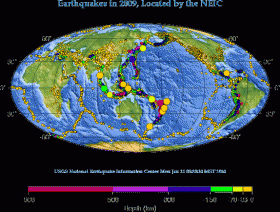
The map shows the locations of earthquakes in 2009 as compiled by the USGS National Earthquake Information Center.
For more information: http://www.usgs.gov/newsroom/article.asp?ID=2378


