
When there is a large earthquake, it basically means that a major geological stress was released. When that happens the earth will literally move. It may not be as dramatic as some motion pictures may show but it does happen. The massive magnitude 8.8 earthquake that struck the west coast of Chile last month moved the entire city of Concepcion at least 10 feet to the west, and shifted other parts of South America as far apart as the Falkland Islands and Fortaleza, Brazil.
When there is a large earthquake, it basically means that a major geological stress was released. When that happens the earth will literally move. It may not be as dramatic as some motion pictures may show but it does happen. The massive magnitude 8.8 earthquake that struck the west coast of Chile last month moved the entire city of Concepcion at least 10 feet to the west, and shifted other parts of South America as far apart as the Falkland Islands and Fortaleza, Brazil.
!ADVERTISEMENT!These preliminary measurements, produced from data gathered by researchers from four universities and several agencies, including geophysicists on the ground in Chile, paint a much clearer picture of the power behind this temblor, believed to be the fifth most powerful since about 1900.
The top four earthquakes ranged from 9.0 to 0.5 on the Richter scale. The top one was also in Chile and happened in 1960. The second most powerful was the Sumatra one in 2004 that caused a massive tsunami.
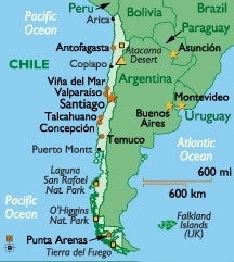
Buenos Aires, the capital of Argentina and across the continent from the quake’s epicenter, moved about 1 inch to the west according to these calculations. Chile’s capital, Santiago, moved about 11 inches to the west/southwest. The cities of Valparaiso and Mendoza, Argentina, northeast of Concepcion, also moved significantly.
The quake’s epicenter was in a region of South America that’s part of the so called ring of fire, an area of major seismic stresses which encircles the Pacific Ocean. All along this line, the tectonic plates on which the continents move press against each other at fault zones. All of the top 5 earthquakes since 1900 happened in this ring of fire.
The February Chilean quake occurred where the Nazca tectonic plate was squeezed under, or subducted, below the adjacent South American plate. Quakes routinely relieve pent up geologic pressures in these convergence zones.
The research team deduced the cities’ movement by comparing precise GPS (global positioning satellite) locations from prior to the major quake to those almost 10 days later. The US Geological Survey reported that there have been dozens of aftershocks, many exceeding magnitude 6.0 or greater, since the initial event February 27. The last shock (6.9) happened March 11 as the new Chilean President was being inaugurated.
GPS monitoring for earthquakes is relatively new but its use promises a great deal of theoretical understanding about tectonics and earthquakes effects.
The Chile earthquake was so powerful that it likely shifted the Earth axis and shortened the length of a day, NASA announced earlier this month.
By speeding up Earth's rotation, the magnitude 8.8 earthquake the fifth strongest ever recorded, according to the USGS—should have shortened an Earth day by 1.26 millionths of a second, according to new computer model calculations by geophysicist Richard Gross of NASA's Jet Propulsion Laboratory in California.
For comparison, the same model estimated that the magnitude 9 Sumatra earthquake in December 2004 shortened the length of a day by 6.8 millionths of a second.
The asteroid impact that may have ended the era of the dinosaurs is estimated as the equivalent of a 11.3 on the Richter scale. This is more than 100 times stronger than the 8.8 Chilean earthquake. Imagine how the world would have moved with that impact.
For further information: http://researchnews.osu.edu/archive/chilemoves.htm


