
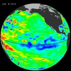
La Niña, "the diva of drought," is peaking, increasing the odds that the Pacific Northwest will have more stormy weather this winter and spring, while the southwestern and southern United States will be dry. Sea surface height data from NASA's Jason-1 and -2 satellites show that the milder repeat of last year's strong La Niña has recently intensified, as seen in the latest Jason-2 image of the Pacific Ocean.
La Niña, "the diva of drought," is peaking, increasing the odds that the Pacific Northwest will have more stormy weather this winter and spring, while the southwestern and southern United States will be dry.
!ADVERTISEMENT!
Sea surface height data from NASA's Jason-1 and -2 satellites show that the milder repeat of last year's strong La Niña has recently intensified, as seen in the latest Jason-2 image of the Pacific Ocean.
The image is based on the average of 10 days of data centered on Jan. 8, 2012. It depicts places where the Pacific sea surface height is higher than normal (due to warm water) as yellow and red, while places where the sea surface is lower than normal (due to cool water) are shown in blues and purples. Green indicates near-normal conditions. The height of the sea surface over a given area is an indicator of ocean temperature and other factors that influence climate.
This is the second consecutive year that the Jason altimetric satellites have measured lower-than-normal sea surface heights in the equatorial Pacific and unusually high sea surface heights in the western Pacific.
"Conditions are ripe for a stormy, wet winter in the Pacific Northwest and a dry, relatively rainless winter in Southern California, the Southwest and the southern tier of the United States," says climatologist Bill Patzert of JPL. "After more than a decade of mostly dry years on the Colorado River watershed and in the American Southwest, and only two normal rain years in the past six years in Southern California, low water supplies are lurking. This La Niña could deepen the drought in the already parched Southwest and could also worsen conditions that have fueled recent deadly wildfires."
NASA will continue to monitor this latest La Niña to see whether it has reached its expected winter peak or continues to strengthen.
Article continues: http://www.sciencedaily.com/releases/2012/01/120119152001.htm
Image credit: NASA/JPL Ocean Surface Topography Team


