
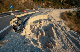
A new technique that can identify catastrophic landslides based on their seismic signals could one day lead to a global system for identifying regions at particular risk from this hazard. Giant landslides involve millions of tonnes of rock and debris moving downslope at speeds often above 110 miles per hour. Such events are rare, but, when they occur, the loss of life and damage to property can be enormous.
A new technique that can identify catastrophic landslides based on their seismic signals could one day lead to a global system for identifying regions at particular risk from this hazard.
Giant landslides involve millions of tonnes of rock and debris moving downslope at speeds often above 110 miles per hour. Such events are rare, but, when they occur, the loss of life and damage to property can be enormous.
!ADVERTISEMENT!
In 2009, several hundred people were killed when typhoon-loosened rock fell from a mountain onto a remote Taiwanese village.
Some 300 landslides of this scale have been documented scientifically since the nineteenth century, but there is still no global system for identifying these events as they are infrequent and often occur in remote areas. It can also take a long time to confirm individual landslides, particularly when they occur in isolated places.
"In Taiwan [in 2009], it took 48 hours for the authorities to realise a landslide had happened, valuable time that could have helped people to be rescued," Göran Ekström, study co-author and professor of earth and environmental sciences at Columbia University, United States, tells SciDev.Net. "In the aftermath of the event, many people were very critical of the government for its slow response."
In a paper published in Science last week (22 March), Ekström and his Columbia colleague Colin Stark say they have found a way of distinguishing the 'surface waves' associated with giant landslides from the background cacophony of seismic noise, particularly from earthquakes, using a data analysis technique.
Applying their technique to historic seismic data that is freely available online, the pair confirmed several known giant landslides and identified others that were previously unverified.
One of the results independently confirmed anecdotal reports that a landslide had struck a remote village in northern Pakistan on 4 January 2010.
Ekström says that a major factor behind their algorithm's success is that scientists now have better images of the Earth's interior, which makes it possible to more realistically model how seismic waves move through the planet. "Open access to the seismological data collected around the world is essential," he says.
One current limitation of the technique is that it overdetects, generating about ten false positives for every genuine landslide. As a result, seismic signals must be verified against visual evidence of landslides on satellite images.
"If the project becomes something for the whole globe, then I think the operational monitoring would be better done by governments and agencies," Ekström tells SciDev.Net.
Continue reading at SciDev.Net.
Landslide image via Shutterstock.


