
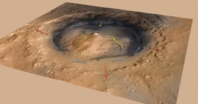
There is a 3.5-mile high Martian mound that scientists suspect preserves evidence of a massive ancient lake. Well maybe not, May be the wind did it. If correct, the research could dilute expectations that the mound holds evidence of a large body of water, which would have important implications for understanding Mars' ancient habitability. Researchers based at Princeton University and the California Institute of Technology suggest that the mound, known as Mount Sharp, most likely emerged as strong winds carried dust and sand into the 96-mile-wide crater in which the mound sits. They report in the journal Geology that air likely rises out of the massive Gale Crater when the Martian surface warms during the day, then sweeps back down its steep walls at night. Though strong along the Gale Crater walls, these slope winds would have died down at the crater's center where the fine dust in the air settled and accumulated to eventually form Mount Sharp, which is close in size to Alaska's Mt. McKinley.
There is a 3.5-mile high Martian mound that scientists suspect preserves evidence of a massive ancient lake. Well maybe not, May be the wind did it. If correct, the research could dilute expectations that the mound holds evidence of a large body of water, which would have important implications for understanding Mars' ancient habitability. Researchers based at Princeton University and the California Institute of Technology suggest that the mound, known as Mount Sharp, most likely emerged as strong winds carried dust and sand into the 96-mile-wide crater in which the mound sits. They report in the journal Geology that air likely rises out of the massive Gale Crater when the Martian surface warms during the day, then sweeps back down its steep walls at night. Though strong along the Gale Crater walls, these slope winds would have died down at the crater's center where the fine dust in the air settled and accumulated to eventually form Mount Sharp, which is close in size to Alaska's Mt. McKinley.
!ADVERTISEMENT!
This approach counters the prevailing theory that Mount Sharp formed from layers of lake bed silt — and could mean that the mound contains less evidence of a past, Earth-like Martian climate than most scientists currently expect. Evidence that Gale Crater once contained a lake in part determined the landing site for the NASA Mars rover Curiosity. The rover touched down near Mount Sharp in August with the purpose of uncovering evidence of a habitable environment, and in December Curiosity found traces of clay, water molecules and organic compounds. Determining the origin of these elements and how they relate to Mount Sharp will be a focus for Curiosity in the coming months.
The mountain appears to be an enormous mound of eroded sedimentary layers sitting on the central peak of Gale. It rises 5.5 km (18,000 ft) above the northern crater floor and 4.5 km (15,000 ft) above the southern crater floor, higher than the southern crater rim. The sediments may have been laid down over an interval of 2 billion years, and may have once completely filled the crater. Some of the lower sediment layers may have originally been deposited on a lake bed, while observations of possibly cross-bedded strata in the upper mound suggest wind based processes.
But the mound itself was likely never under water, though a body of water could have existed in the moat around the base of Mount Sharp, said study co-author Kevin Lewis, a Princeton associate research scholar in geosciences and a participating scientist on the Curiosity rover mission, Mars Science Laboratory. The quest to determine whether Mars could have at one time supported life might be better directed elsewhere, he said.
"Our work doesn't preclude the existence of lakes in Gale Crater, but suggests that the bulk of the material in Mount Sharp was deposited largely by the wind," said Lewis a planetary science postdoctoral scholar at Caltech.
"Every day and night you have these strong winds that flow up and down the steep topographic slopes. It turns out that a mound like this would be a natural thing to form in a crater like Gale," Lewis said. "Contrary to our expectations, Mount Sharp could have essentially formed as a free-standing pile of sediment that never filled the crater."
"These sedimentary mounds could still record millions of years of Martian climate history," Lewis said. "This is how we learn about Earth's history, by finding the most complete sedimentary records we can and going through layer by layer. One way or another, we're going to get an incredible history book of all the events going on while that sediment was being deposited. I think Mount Sharp will still provide an incredible story to read. It just might not have been a lake."
Kite developed a computer model to test how wind circulation patterns would affect the deposition and erosion of wind-blown sediment within a crater like Gale. The researchers found that slope winds that constantly exited and reentered Gale Crater could limit the deposition of sediments near the crater rim, while building up a mound in the center of the crater, even if the ground were bare from the start, Lewis said.
Satellite observations had previously detected water-related mineral signatures within the lower portion of Mount Sharp. While this suggested that the lower portion might have been series of lakebeds, portions of the upper mound were more ambiguous, Lewis said. First of all, the upper layers of the mound are higher than the crater walls in several places. Also, Gale Crater sits on the edge of Mars' northern lowlands. If it had been filled with water to near the height of Mount Sharp then the entire northern hemisphere would have been flooded.
"If the mechanism we describe is correct, it would tell us a lot about Mars and how it operates because Mount Sharp is only one of a class of enigmatic sedimentary mounds observed on Mars," Lewis said.
The paper, "Growth and form of the mound in Gale Crater, Mars: Slope wind enhanced erosion and transport," was published in the May 2013 issue of the journal Geology.
For further information see Wind Built Mountain.
Mt. Sharp image by NASA/JPL-Caltech.


