
Prolonged cold snaps on the East Coast, California drought and frozen mornings in the South all have something in common – the atmospheric jet stream which transports weather systems that’s taken to meandering all over North America.
Rutgers University climate scientist Jennifer Francis and colleagues link that wavy jet stream to a warming Arctic, where climate changes near the top of the world are happening faster than in Earth’s middle latitudes.
A new study from Francis and University of Wisconsin-Madison scientist Stephen Vavrus, published in IOPscience, backs up that theory, with evidence linking regional and seasonal conditions in the Arctic to deeper north-south jet stream waves which will lead to more extreme weather across the country.
“The real story is how persistent the pattern has been. It’s been this way nearly continually since December 2013…Warm in the west, cold in the east,” Francis said. “We think with the warming Arctic these types of very wavy patterns, although probably not in the same locations, will happen more often in the future.”
This research has been controversial since the Hurricane Sandy disaster, when the wavy jet stream steered the storm on its sharp left turn and smack into the Jersey Shore. Francis and other researchers say the jet stream’s configuration was a key ingredient in the monster storm.
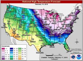
Very wavy jet-stream patterns have been occurring more often since the 1990s, Francis says, and are now affecting weather around the northern hemisphere. This mid-February cold snap, for example, that has left millions of people waking up to below-zero and single-digit temperatures, might not be as deep as some southward dips, called troughs, in the jet stream. But the overall pattern has been around for weeks, and is also responsible for Boston’s record snowfall this winter and the worsening drought in western states.
In contrast, an opposite pattern in winter 2012 led to more than 3,000 high winter temperature records being broken in the eastern U.S., Francis notes.
“California is still dealing with this record-breaking drought, and Alaska is having one of its warmest winters on record,” Francis said.
Temperature map image credit National Weather Service.
Read more at Rutgers University.


