In a new study published today, scientists from the U.S. Geological Survey found that the remote northern Alaska coast has some of the highest shoreline erosion rates in the world.Analyzing over half a century of shoreline change data, scientists found the pattern is extremely variable with most of the coast retreating at rates of more than 1 meter a year.
“Coastal erosion along the Arctic coast of Alaska is threatening Native Alaskan villages, sensitive ecosystems, energy and defense related infrastructure, and large tracts of Native Alaskan, State, and Federally managed land,” said Suzette Kimball, acting director of the USGS.
Scientists studied more than 1600 kilometers of the Alaskan coast between the U.S. Canadian border and Icy Cape and found the average rate of shoreline change, taking into account beaches that are both eroding and expanding, was -1.4 meters per year. Of those beaches eroding, the most extreme case exceeded 18.6 meters per year.
“This report provides invaluable objective data to help native communities, scientists and land managers understand natural changes and human impacts on the Alaskan coast,” said Ann Gibbs, USGS Geologist and lead author of the new report.
Coastlines change in response to a variety of factors, including changes in the amount of available sediment, storm impacts, sea-level rise and human activities. How much a coast erodes or expands in any given location is due to some combination of these factors, which vary from place to place.
"There is increasing need for this kind of comprehensive assessment in all coastal environments to guide managed response to sea-level rise and storm impacts," said Dr. Bruce Richmond of the USGS. "It is very difficult to predict what may happen in the future without a solid understanding of what has happened in the past. Comprehensive regional studies such as this are an important tool to better understand coastal change. ”
Compared to other coastal areas of the U.S., where four or more historical shoreline data sets are available, generally back to the mid-1800s, shoreline data for the coast of Alaska are limited. The researchers used two historical data sources, from the 1940s and 2000s, such as maps and aerial photographs, as well as modern data like lidar, or “light detection and ranging,” to measure shoreline change at more than 26,567 locations.
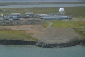
Image from 2006 shows the Barter Island long-range radar station landfill threatened by coastal erosion. The landfill was subsequently relocated further inland, however, the coastal bluffs continue to retreat. Credit Bruce Richmond/Ann Gibbs, USGS.
Read more at USGS.


