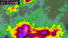
A new graphic created by NASA and the Japan Aerospace Exploration Agency illustrates the severity of a recent rainstorm that caused widespread flooding in Louisiana this week, killing 11 people and forcing tens of thousands of residents from their homes.
A new graphic created by NASA and the Japan Aerospace Exploration Agency illustrates the severity of a recent rainstorm that caused widespread flooding in Louisiana this week, killing 11 people and forcing tens of thousands of residents from their homes.
As much as 31 inches of rain fell in the southeastern U.S., much of it over a period of just three days, in what forecasters classified a 500-year storm event.
Continue reading at Yale News.
Image: NASA's IMERG data from Aug. 8 to Aug. 15, 2016 showed over 20 inches (508 mm) of rainfall was estimated in large areas of southeastern Louisiana and extreme southern Mississippi. Even greater rainfall totals of 30 inches (762 mm) were indicated in a small area of Louisiana west of Lake Pontchartrain.
Credits: NASA/JAXA, Hal Pierce


