Pollution from the controlled fires that burn across Brazil's São Paulo state during the sugarcane-harvesting season has a negative impact on infant health nearby. But the health of those same infants likely benefits from the economic opportunities the fires bring to their parents.
Researchers at Princeton and Duke universities gathered information from satellites, pollution monitors and birth records to untangle those competing influences and accurately measure the impact of pollution from the fires. They found that exposure to pollution from the fires in the last few months of gestation leads to earlier birth and smaller babies, and they found some evidence of increased fetal mortality. Conditions in early life, including in utero, have been shown to affect children's long-term outcomes, not only in terms of health but also their educational and economic success.
The findings suggest that policymakers in Brazil and across the developing world should pay more attention to the negative health impact of pollution from fires that are often part of traditional farming techniques, even though the pollution doesn't usually reach levels considered dangerous by industrial standards.
Continue reading at Princeton University
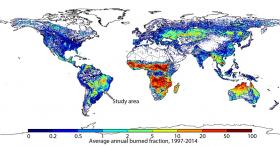
Map: This map shows the average share of each 0.25 longitude by 0.25 latitude square that burned annually from 1997 to 2004. The researchers’ study site is located in south-central Brazil, where a regional hot spot in fire activity can be seen.
Map source: Global Fire Emissions Database, http://www.globalfiredata.org/


