Researchers from the National Institute of Standards and Technology (NIST) and the University of Colorado Boulder have demonstrated a new mobile, ground-based system that could scan and map atmospheric gas plumes over kilometer distances.
The system uses an eye-safe laser instrument to send light that “combs” the air to a flying multi-copter and analyzes the colors of light absorbed along the way to identify gas signatures in near-real time.
The “comb and copter” system may be useful to scan for leaks in oil and gas fields, study the mixing of auto emissions and other gases in the boundary between the Earth’s surface and the next layer of the atmosphere, or, with planned upgrades, detect pollutants or chemical threats and their sources.
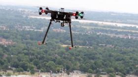
As described in Optica, researchers used the comb light to measure carbon dioxide, methane and water vapor -- greenhouse gases that heat the atmosphere -- along a 2-kilometer (1.24 mile) round trip path between a telescope on a NIST Boulder laboratory roof and a retroreflector mounted on a small, unmanned aircraft. The multi-copter hovered in selected spots to measure gases along a horizontal path and at various altitudes of up to 120 meters (400 feet). Higher-altitude flights are technically feasible but currently limited by unmanned aerial vehicle flight rules.
Continue reading at National Institute of Standards and Technology (NIST)
Image: NIST has combined a laser instrument that 'combs' the air with a flying multi-copter to scan and map atmospheric gases over kilometer distances. (Credit: NIST)


