Tropical Storm Greg appears to be less-rounded and more elongated on satellite imagery from NOAA's GOES-West satellite. Greg is still over 1,500 miles east of Hawaii.
Tropical Storm Greg appears to be less-rounded and more elongated on satellite imagery from NOAA's GOES-West satellite. Greg is still over 1,500 miles east of Hawaii.
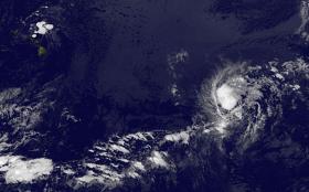
NOAA's GOES-West satellite captured an infrared image of Tropical Storm Greg on July 24 at 8 a.m. EDT (1200 UTC). The image revealed a less-rounded tropical cyclone. The National Hurricane Center noted the reason for the change in shape: "Greg's convective structure is gradually deteriorating, likely due to very dry air in the surrounding atmosphere."
NOAA manages the GOES series of satellites, and NASA uses the satellite data to create images and animations. The image was created by the NASA/NOAA GOES Project at NASA's Goddard Space Flight Center in Greenbelt, Maryland.
At 11 a.m. EDT (1500 UTC), the center of Tropical Storm Greg was located near 14.6 degrees north latitude and 133.2 degrees west longitude. That's about 1,515 miles (2,440 km) east of South Point Hawaii. Greg was moving toward the west near 12 mph (19 kph). A west-northwestward or northwestward motion at a slower forward speed is expected during the next couple of days.
Read more at NASA/Goddard Space Flight Center
Image: NOAA's GOES-West satellite captured this infrared image of Tropical Storm Greg on July 24 at 8 a.m. EDT (1200 UTC). Greg is located over 1,500 miles east of Hawaii. (Credit: NASA/NOAA GOES Project)


