Tropical Storm Nalgae can’t seem to get a break from vertical wind shear. The storm has been dealing with wind shear since it formed and NASA’s Terra satellite observed that was still the case on August 4.
Tropical Storm Nalgae can’t seem to get a break from vertical wind shear. The storm has been dealing with wind shear since it formed and NASA’s Terra satellite observed that was still the case on August 4.
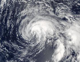
On August 4, 2017 at 0210 UTC (Aug. 3 at 10:10 p.m. EDT), NASA’s Aqua satellite passed over the Northwestern Pacific Ocean and the Moderate Resolution Imaging Spectroradiometer or MODIS instrument captured a visible-light image of the storm. The image revealed that Nalgae’s strongest thunderstorms were being pushed north of the large low-level circulation center due to increasing southerly vertical wind shear.
On August 4, 2017 at 11 a.m. EDT (1500 UTC), Nalgae’s maximum sustained winds were near 46 mph (40 knots/74 kph). Nalgae was centered near 31.3 degrees north latitude and 162.7 degrees east longitude, about 561 nautical miles northeast of Minami Tori Shima. Nalgae has tracked to the north-northwestward at 10.3 mph (9 knots/16.6 kph).
Read more at NASA/Goddard Space Flight Center
Image: On Aug. 4 at 0210 UTC (Aug. 3 at 10:10 p.m. EDT, NASA's Aqua satellite saw that Nalgae's strongest thunderstorms were being pushed north from wind shear. (Credit: NASA Goddard MODIS Rapid Response Team)


