An innovation providing key clues to how humans might manage forests and cities to cool the planet is taking flight. Cornell researchers are using drone technology to more accurately measure surface reflectivity on the landscape, a technological advance that could offer a new way to manage climate change.
“When making predictions about climate change, it’s critical that scientists understand how much energy the earth is absorbing and retaining,” said Charlotte Levy, a doctoral candidate who presented a talk on her research at the annual Ecological Society of America meeting, in Portland, Oregon, Aug. 8.
When a surface reflects solar energy rather than absorbing it as heat, the result is major cooling, locally and globally. The scientific term for the measurement of surface reflectivity is albedo. “Albedo is important to understand because it’s one of the main controls for the Earth’s overall energy budget,” said Levy, whose research project is directed by Timothy Fahey, professor of natural resources. She is advised by Christine Goodale, professor of ecology and evolutionary biology.
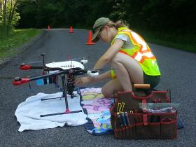
Using drones, also known as unmanned aerial vehicles, Levy and others have developed a novel method of measuring albedo with more flexibility and accuracy than was possible before.
Continue reading at Cornell University
Photo via Cornell University


