
NASA analyzed the soil moisture in southeastern Texas before and after Harvey made landfall and found the ground was already somewhat saturated. NASA-NOAA’s Suomi NPP Satellite provided a night-time look at Harvey after it moved into the Gulf of Mexico, and NOAA’s GOES East satellite provided a look at the storm after it made its final landfall near the Texas-Louisiana border on Aug. 30.
NASA analyzed the soil moisture in southeastern Texas before and after Harvey made landfall and found the ground was already somewhat saturated. NASA-NOAA’s Suomi NPP Satellite provided a night-time look at Harvey after it moved into the Gulf of Mexico, and NOAA’s GOES East satellite provided a look at the storm after it made its final landfall near the Texas-Louisiana border on Aug. 30.
NASA Looks at Soil Moisture
At NASA's Jet Propulsion Laboratory in Pasadena, Calif. images of soil moisture conditions in Texas near Houston, were generated using data from NASA's Soil Moisture Active Passive (SMAP) satellite. The images captured conditions before and after the landfall of Hurricane Harvey. The images can be used to monitor changing ground conditions due to Harvey's rainfall.
SMAP observations from Aug. 21 and 22 showed that soil surface conditions were already very wet a few days before the hurricane made landfall, with moisture levels in the 20 to 40 percent range. Such saturated soil surfaces contributed to the inability of water to infiltrate more deeply into soils, thereby increasing the likelihood of flooding. After Harvey made landfall, the southwest portion of Houston became exceptionally wet. SMAP captured data on Aug. 25 and 26 that signaled the arrival of heavy rains and widespread flooding.
Continue reading at NASA / Goddard Space Flight Center
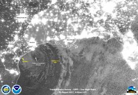
Image: On Aug. 29 at 3:03 a.m. CDT the VIIRS instrument aboard NASA-NOAA’s Suomi NPP satellite captured a night-time image of Harvey that showed the center of circulation had moved back into the Gulf of Mexico.
Credits: NASA / NOAA / UWM-CIMSS, William Straka III


