Hurricane response crews from the U.S. Geological Survey are installing storm-tide sensors at key locations along Florida’s southeast and southwest coastlines in advance of Hurricane Irma.
Under a mission assignment from the Federal Emergency Management Agency, the USGS is currently deploying approximately 58 storm tide sensors, 24 barometers and five rapid deployment gauges, and is consulting with federal and state partners about the need for similar equipment for other coastal areas farther north along the coastlines.
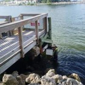
These storm-tide sensors, housed in vented steel pipes a few inches wide and about a foot long, are being installed on bridges, piers, and other structures that have a good chance of surviving a storm surge during a hurricane. The information they collect will help define the depth and duration of a storm-surge, as well as the time of its arrival and retreat. That information will help public officials assess storm damage, discern between wind and flood damage, and improve computer models used to forecast future floods. You can track the storm-surge sensor deployment and see some of the incoming data via the USGS “Flood Viewer”.
Continue reading at USGS.
Photo via USGS.


