Hurricane Maria has caused catastrophic flooding in Puerto Rico and left a wake of heavy rainfall that NASA measured using a fleet of satellites in space. NASA satellite imagery also saw Maria's eye close up as it tracked across Puerto Rico and re-open after its exit.
Hurricane Maria has caused catastrophic flooding in Puerto Rico and left a wake of heavy rainfall that NASA measured using a fleet of satellites in space. NASA satellite imagery also saw Maria's eye close up as it tracked across Puerto Rico and re-open after its exit.
The Global Precipitation Measurement mission or GPM core satellite, a joint mission between NASA and the Japan Aerospace Exploration Agency can measure rainfall from space. That rainfall data, combined with data from other satellites provided a tally of Hurricane Maria's rainfall over the course of several days.
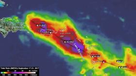
At NASA's Goddard Space Flight Center in Greenbelt, Maryland, NASA's Integrated Multi-satellitE Retrievals for GPM (IMERG) data were used to estimate the total amount of rain that Hurricane Maria dropped from Sept. 17 to early Sept. 21, 2017. During that period Maria dropped heavy rain in the Leeward Islands, Virgin Islands and Puerto Rico. IMERG estimated that rainfall totals greater than 10 inches (254 mm) were common along Maria's track. IMERG rainfall estimates indicated that more than 20 inches (512 mm) of rain fell over a large part of Puerto Rico.
Continue reading at NASA / Goddard Space Flight Center
Image: From Sept. 17 to early Sept. 21, 2017 NASA's IMERG estimated that rainfall totals greater than 10 inches (254 mm) were common along Maria's track. IMERG rainfall estimates indicated that more than 20 inches (512 mm) of rain fell over a large part of Puerto Rico. During that period Maria dropped heavy rain in the Leeward Islands, Virgin Islands and Puerto Rico.
Credit: NASA


