Carbon dioxide measured by a NASA satellite pinpoints sources of the gas from human and volcanic activities, which may help monitor greenhouse gases responsible for climate change.
Late last month, a stratovolcano in Bali named Mount Agung began to smoke. Little earthquakes trembled beneath the mountain. Officials have since evacuated thousands of people to prevent what happened when Agung erupted in 1963, killing more than 1,000 people.
Before volcanoes erupt, there are often warning signs. Tiny earthquakes rarely felt by humans but sensed by seismographs emanate from the volcano. Plumes of water vapor rise from the crater. When the volcano begins to emit gases like carbon dioxide and sulfur dioxide, eruption may be imminent.
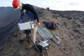
But getting close to the top of a volcano is dangerous work. Using remote sensing to detect rising carbon dioxide and sulfur dioxide emissions without endangering people or equipment would greatly increase human understanding of volcanoes. Remote sensing emissions could prevent humanitarian disasters—and false alarms.
Read more at Michigan Technological University
Image: Simon Carn measures gas emissions from Mount Yasur in the island nation of Vanuatu in 2014. (Credit: Simon Carn)


