On Jan. 8, Tropical Cyclone Irving was hurricane-force in the Southern Indian Ocean. The Global Precipitation Measurement Mission or GPM core satellite passed overhead and measured cloud heights and rainfall rates in the powerful storm.
On Jan. 8, Tropical Cyclone Irving was hurricane-force in the Southern Indian Ocean. The Global Precipitation Measurement Mission or GPM core satellite passed overhead and measured cloud heights and rainfall rates in the powerful storm.
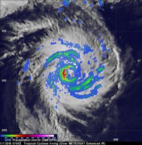
Tropical Cyclone Irving formed in the South Indian Ocean on January 6, 2018. Irving posed no threat to land because it developed over the open ocean far to the west of Australia. GPM's core observatory satellite had an excellent view of Irving's eye on January 2018 at 2:06 a.m. EST (0706 UTC). The well-defined rainfall patterns within Irving were clearly shown by GPM's Microwave Imager (GMI) and Dual Frequency Precipitation Radar (DPR) data. Very heavy rainfall was shown in the western side of Irving's eye wall. GPM's Radar (DPR Ku Band) found rain in that side of the tropical cyclone falling at a rate of over 93 mm (3.7 inches) per hour.
Tropical cyclone Irving's 3-D precipitation structure was examined by GPM's radar (DPR Ku Band). GPM's radar slice through the center of tropical cyclone Irving showed that the powerful storms in the western side of Irving's eye wall were reaching altitudes of about 17 km (10.5 miles). GPM is a joint mission between NASA and the Japan Aerospace Exploration Agency, JAXA.
Read more at NASA/Goddard Space Flight Center
Image: On Jan. 7, GPM found very heavy rainfall in the western side of Irving's eye wall at a rate of over 93 mm (3.7 inches) per hour. (Credit: NASA/JAXA, Hal Pierce)


